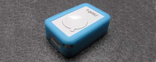
I recently reviewed the ATP GPS PhotoFinder mini photo geotagging module. I liked the concept, but found some issues with usability. Today I have a similar product for you. It’s the i-gotU USB GPS Travel Logger GT-120 from Mobile Action. It’s smaller and even easier to use than the PhotoFinder. Let’s take a look.
If you are not familiar with this type of geotagging product, it interfaces with any camera or mobile phone, so that the images that you snap can be tagged with the GPS longitude and latitude coordinates where they were taken. The i-gotU goes a step farther in that it will allow you to upload your trips to a special free online server, create nifty little animated movies of your travels and share them with anyone.
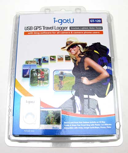
Hardware Specifications
Dimension: 44.5 x 28.5 x 13 mm
Weight: 20g
Built-in SiRF StarIII 65nm low-power chipset
Built-in GPS patch antenna.
Built-in flash memory. 65000 waypoints for 30 days( when the logging interval is 15 seconds and use it 8 hours per day)
Built-in 230mAh Lithium-ion battery.
Operation time: Up to 30 hours ( when the logging interval is 15 seconds)
2 LED for tracking and battery/charger status indication.
Average acquisition time for cold start: < 35 seconds, hot start: < 1 seconds.
USB 1.1 interface for PC connection
Operation temperature: -10 to + 50 degrees centigrade
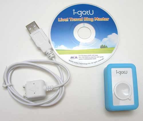
Package Contents
i-gotU module
USB cable
Mini CD with software and manual
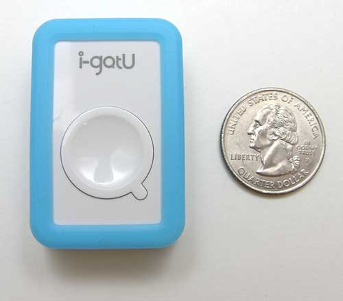
The i-gotU module is a very small White plastic rectangle, with one button. The Blue silicone skin is removable. There are two LEDs (not visible in this photo) located on either side of the power button. One is Blue and one is Red. When the module is powered on, the Blue LED will blink every 15 or so seconds. If there is a GPS signal, the Red LED will also blink.
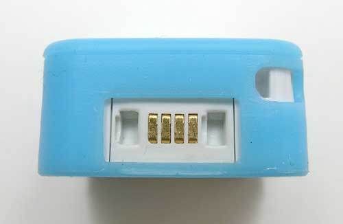
One end has the proprietary USB connector and a lanyard attachment eyelet. Surprisingly, no lanyard or keychain was included in the package.
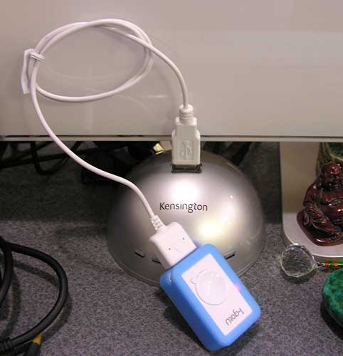
Before you use the i-gotU, you must first charge it using the included USB cable. The initial charge requires 4hrs and subsequent charges will require 2hrs.
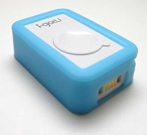
Operating this device is about as simple as it can be. Just hold down the only button for a couple of seconds till you see the Blue LED blink. Then go outside to allow it to get a GPS lock. You will know when you have a signal, when you see the Red LED blinking along with the Blue one. Most of the time, this only requires a minute or so. Now all you have to do is carry the i-gotU along with you, while snapping pictures with a camera that has the correct time set. I used my cellphone during the review. Since mobile phones typically set the time via the carrier, I didn’t need to worry about that aspect.
When you’re finished for the day, load up the included software on a Windows PC and launch it.
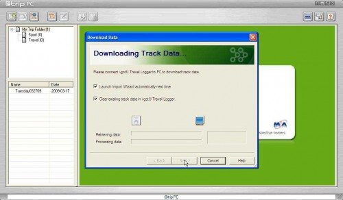
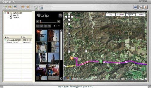
The @Trip software has an easy user friendly interface. Clicking the Import GPS Track button in the upper Left corner will guide you through the steps of retrieving info off the i-gotU module. Click on screenshots for full size images.
You will be prompted to connect the i-gotU to your PC with the included USB cable. Once you do, it will automatically start downloading the info.
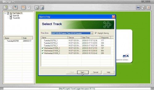
You will then be presented with a list of trips. In the screenshot above, I have 3 separate trips for that day as I had powered the i-gotU on and off at the start and end of each trip. The software will automatically select multiple trips for that day. If you want to combine them all together, click Next, otherwise, you can uncheck the trips you don’t want to include.
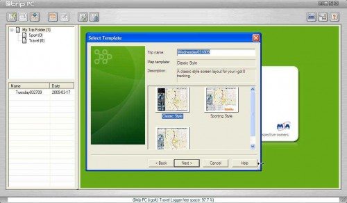
You then have the option of three different trip styles. More about that in a bit.
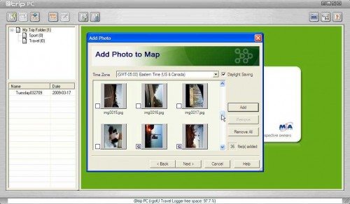
The next step is to import the images that you took while the i-gotU was powered on. The images that were taken during the same time that the module powered was on and receiving a GPS signal, will have a G next to them.
After the images are imported, your trip will be shown using Google Maps, complete with start and end points. Depending on the style that you selected, imported images will show up on the sidebar. If you combined multiple trips into one, each leg of the trip will be a different color.
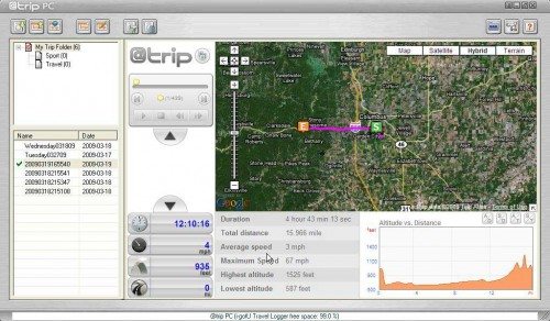
If you picked the sport style, you will see some some cool info such as distance traveled during the trip, max speed, altitude, etc. All three styles allow you to ‘play’ the trip and if you want to share it with your friends, you can upload it to the @Trip website for free.
It’s pretty fun to watch the animated trips. Here are two examples. The images aren’t that great since I snapped them really quickly with my phone. But it gives you an idea of what you could do with this device and your camera.
http://www.a-trip.com/tracks/view/16297 – Sport style trip
http://www.a-trip.com/tracks/view/16202 – Classic style trip
There are two things is one thing that I found missing with this product. It does not have the ability for imported images to automatically map to the last known coordinates for those times when the module did not have a GPS signal. For example, if you are driving to a museum and have the i-gotU on your car’s dash, it will record your trip and the images that you snapped along the way. But, if you take the i-gotU inside a building where it can’t get a signal and you continue to snap pix, the trip won’t include those photos. It would be great if the software would automatically allow you to map images to the last known location. That said, the software will allow you to manually map an image to a specific waypoint. But, it’s not very convenient or straightforward as to which waypoint you should pick.
The other issue is that the software does not add the longitude and latitude coordinates to the image EXIF data. It does add that data to the imported images that make up the trip, so you can view your trip through the web interface and then copy the images back out. But that’s a pretty annoying way to do it. There really needs to be an option to geotag your original images. **Update 04/11/08 This product does add longitude and latitude info to images.
I found this module and software to be much easier to use than the ATP PhotoFinder mini. You don’t have to worry about missing the time zone setting as you only need to set once the first time you import data from the i-gotU module. There’s even a daylight savings time switch. It’s also a lot faster at exporting data than the PhotoFinder.
I didn’t have problems with it keeping a GPS signal even while driving over 60MPH. The images that I took matched up very well with the locations where I snapped them, even if I was driving at the time.
The i-gotU is a fun and relatively inexpensive little gadget to play with if your camera does not already have geotagging features. You can find this USB version and a Bluetooth version at eXpansys. And FYI.. if you want to skip the whole separate module thing and you already own a Symbian, Windows Mobile or a phone that supports Java, you can download the free @Trip software for your phone. It will upload your images to the @Trip website.
How many of you out there use a geotagging phone or camera for your photos?
ESR for MagSafe Wallet, 5-Card Holder With RFID Blocking, MagSafe Sticker Included, Slim Magnetic Wallet for iPhone 17/16/15/14/13/12 Series and Selected Samsung Devices, Not for 13/12 Mini, Black
(as of February 20, 2026 12:30 GMT -06:00 - More infoProduct prices and availability are accurate as of the date/time indicated and are subject to change. Any price and availability information displayed on [relevant Amazon Site(s), as applicable] at the time of purchase will apply to the purchase of this product.)Apple iPhone FineWoven Wallet with MagSafe – Black
(as of February 20, 2026 12:30 GMT -06:00 - More infoProduct prices and availability are accurate as of the date/time indicated and are subject to change. Any price and availability information displayed on [relevant Amazon Site(s), as applicable] at the time of purchase will apply to the purchase of this product.)Product Information
| Price: | $72.99 |
| Manufacturer: | Mobile Action |
| Pros: |
|
| Cons: |
|



Gadgeteer Comment Policy - Please read before commenting
And I am circling this already for some weeks like a vulture around a dead zebra. Thanks for a great review, Julie! Do I understand correctly that it essentially logs your gps travel path along with the time, and it matches the exif time of the picture with where-I-was-at-that time gps coordinates?
Also, could you possibly hint on the battery life?
Juraj
@Sebastien I agree that the fact that it doesn’t allow you to update your photos with the GPS data, is a deal breaker for some. But, it appears that this product is being marketed as a travel logger instead of a photo tagger.
@Juraj Yes, that’s exactly what this product does. It logs way points while you are traveling and then you can import photos into the trip. The ones that have the same time as the gps data will add in automatically. Battery life seems to be really good. They claim 30hrs. I only used mine for 8hrs at a time.
Hi Julie,
Thanks for the review. However, this sounds like a half-baked solution. If the files are not permenately enhanced with the longitude and latitude incorporated within the EXIF, this doesn’t appear to be a permanent or standard aleternative. Moreover, I shoot Canon RAW (.CR2) and would like to find a Geotagging solution, not a web service, travel mapping software. I guess I still need to find more of an appliance that serves as a GPS logger, that would allow for updating my photos when needed. The rest I’ll manage myself 😉
To be continued…
Love the idea and the form..But no mac compatibility??
@Chris Yeah, that’s an issue…
hi there. cheers for the info. I actually think that it does Geotag the original pics. I tried it and it seems to work. I geotagged two pics on a trail through the software. When I opened the original pics with picasa, they both had a little geotag label and when I uploaded them on the internet it placed them on the map automatically. Perhaps some software update (?)
(version GT-120)
Hi Julie, Thanks for the info. This tiny GPS gear actually does the Geotagging. I know it because I am very familiar with this product. The supplied software will ask to write or not the GPS info into original pics while doing the processes of trip download. In additional, this device can be used up to 120 hours depends on your setting time interval. My favorite time interval is 1 second. Although I can only use it for around 9 hours, I get the most accurate traveling path which is exactly what I need. I love this device; it’s a good tool to help me to edit my travel blog quickly. A route with mapped photo can tell everything.
Hi Julie —
I am searching for a great GPS / datalogger that is Mac compatible. It is proving surprisingly hard to find, but the USGlobalSat BT335 seems to be the most promising right now.
Have you tried it?
All my best,
– Chris
@Chris No, I’ve not tried that one. I’ll try to check it out.
Upon further testing, I found that I was originally mistaken. This product does add longitude and latitude coordinates to photo EXIF info.
Hello,
I’ve just bought one of these to track where my cats go when they are on their adventures.
As I use Linux I was initially worried about lack of support but happily someone has created a command line utility which works under Mac os / Linux which allows you to pull the data off it in a GPX format which can then be used by Google maps etc.
It doesn’t do the photo matching up thing, but if you’re using it just as a GPS data logger it shouldn’t matter.
You can find the software here: https://launchpad.net/igotu2gpx
Hi Nermal,
Great news to me as a mac geek.
Btw, if guys want a cheaper price for i-gotU GPS Log or prefer other online shops. I recommend buygpsnow.com. http://www.buygpsnow.com/search.aspx?keyword=i-gotu
Hi Julie,
1) How do you keep the device from starting accidently when you keep it in your pocket? Is there a container you use to prevent accidental contacts with the device’s start up button?
2) Can the iGotU be used when you keep it in your pocket?
Thanks!
@Kenny You have to hold down the button in order to power on the device. So it probably won’t do this in your pocket. I don’t think it will work in your pocket as it needs a clear view of the sky. The fabric of your pants will probably hinder reception.
Great review Julie, Can I ask a (perhaps) stupid question. Will it only geotag photos taken at the exact time that it has logged a GPS coordinate or can it ‘join up’ the GPS points that it has and then decide roughly where you were when you took a photo between waypoints. Because unless you are setting GPS points very frequently e.g. every few seconds, the chances are that you will not be taking GPS coordinate at the same time as taking a photo. Thanks!
@Brian the i-gotU logs a new waypoint every 15 seconds, so it should be pretty accurate.
The best part of i-gotU is their travel blog.
http://www.a-trip.com
Personally, I think it is better than Everytrail.
You must give it a try, it is awesome!!!!!
Hey Nermal,
How did you go using this to track your cats ? I’m thinking of the same thing but if I just attach it to their collars, it will hang underneath their neck. Won’t the cat’s neck and head obscure the necessary view of the sky most of the time ?
Thanks !
Hi everybody,
I have just received my i-gotU GT-120 and as yet, have not tried the operation.
My question is that I am about to travel around the world, and so pass many time zones.
For ease of use, would it be better the set my cameras and GT-120 to G.M.Time and leave it on that, rather than trying to remember at each stop to reset the cameras and GT-120 to local time and date?
Over seven weeks, I am sure to forget the change the settings.
Any help would be appreciated.
Thanks.
Hi there
Anyone tried it in the pocket of hi/her pants?
Pretty much useless if there’s no reception in the pocket. I don’t want to wear it around my neck with a lanyard.
Will it work in a photo backpack?
How do you guys carry this little gadget?
Regards
Marcel
I accidentally put my i-gotU device in the zipper-outsidepocket of a wintercoat and to my surprise my walking trip was 100% correct on the Google map! To check I did it 2x again and the results were fine.
Regards, Dick
I have bought my i-gotU last year and I’m very happy with it.
I’ve made the GR20 (Corsica) where it has proved that it’s fully waterproof, trip in the USA with an helicopter flight above the Grand Canyon, multiple motorcycle trips (i-got in one of my pocket) and I also use it when I’m running (the new software suite has an ad hoc sport software). It logs almost everything, except when you really are deeply in a forest.
Regards
Fof
I used this product to track my cheating wife in the act. IT WORKS!! I was able to see her every movement, every stop and how long she was there. Using Google maps I was able to determine where she and her boyfriend met at a parking lot, ate lunch, parked for a quickie and then dropped him off at his car again. Not pleasant news. But if you need to know. This is the device for you! She was floored when I confronted her with my knowledge of where she had been and when she had been there. And I have never told her about the IGotU unit in her car HAHAHAHAHAHA!!!
Is it possible to decrease the waypoint intervall to e.g. 1 second (which is what the average GPS receiver produces)?
Somewhat important for me…
Julie, it’s now 2011 – does the i-gotU GT-120 now have mac compatibility?
@EV No, there doesn’t appear to be a Mac compatible application yet…
Thanks for the review. I would like to buy a GPS logger and I think the GT-120 is the small in the market.
1) Please tell me, the software writes the GPS info in RAW photos?
2) Is there any solution to add the latest known GPS info in photos when there is no GPS signal? (In case that you enter in a building).
Thanks 🙂
Nice review Julie but here we are half way through 2012!
Is there still no Mac compatible gadget yet?
@Mark Ford Not sure, I really haven’t kept up with the GPS travel logger gadgets since doing that particular review. Maybe someone else can comment if they’ve found something for the Mac.
what tracking interval is the most accurate and the best one for a simple walk in the park. what settings do you recommend, for the most accurate.
As we are now in 2015, does anybody know if there is software available for MAC or I-pad/phone.
if there is an other solution please let me know
Mac user: you can use igotu2gpx to download the data off the logger. You can then use gpsphotolinker (free) or HoudaGeo (not free) to link the GPS-data to your photos.
https://launchpad.net/igotu2gpx
http://www.earlyinnovations.com/gpsphotolinker/
https://www.houdah.com/houdahGeo/
I got this info from: http://www.gpsshop.nl/product-reviews/65092/i-gotu-gt-120-usb-gps-receiver-travel-logger.html
An earlier commenter pointed to Linux software for this GPS-logger.
https://launchpad.net/igotu2gpx
It seems you can also use this software for mac osx