Product Requirements:
PC with a Pentium processor (90MHz or
faster), Microsoft Windows 95 or a later version of Windows, 32MB RAM, 4x or
faster CD-ROM drive
Device:
Mobile Pocket PC Device, 32MB RAM and a 96MB
external memory card or 64MB RAM
It wasn’t long ago that I was posting a diary
entry telling how I wanted my next vehicle to have a factory installed GPS
system. An interesting discussion ensued, both on the
Gadgeteer
BB and in my private e-mail. I had just bought my SUV about 6 months before
I decided that GPS was a necessity, so it wasn’t exactly practical to trade my
Ford Expedition in anytime soon. More realistically, I needed to find an
after-market GPS solution. Since I just so happened to have an IPAQ 5455 that
wasn’t getting daily use, I knew that a Pocket PC based scenario would be the
ideal set-up for me.
I have to admit that before I began writing this review, I had zero
experience with GPS navigation. While I can be pretty handy with an atlas and I
have never been afraid to ask for directions, the next logical step had just
never occurred. Enter the Destinator
Personal Navigation System.
Believe it or not, Julie just happened to have an unopened Destinator
sitting at her house; it was something that she had requested for review, but
hadn’t gotten to yet. After hearing how cool I thought it would be to have GPS
in my vehicle, she decided to kill two birds with one stone: she got me
to write the review, and she made my day. Pretty cool, huh?
☺
When I received the Destinator package, I was a
little bit surprised at it’s simplicity. It turned out to be a matter of
installing some software and maps, then just plugging the cables in. Hey, anyone
could do this!
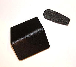
Inside the box was a small black GPS antenna
receiver with attached cables, a cigarette lighter adapter/charger with attached
cables, as well as the CD-ROM which contained the Destinator software,
NAVTECH® maps detailed to the house level,
embedded points of interest (POI) in the maps, a user manual and a tutorial.
There was also a canvas drawstring sack for storing the system when I wasn’t
using it, so of course – I use it for something else entirely. Unfortunately,
there was no method included for mounting or holding my iPAQ when I was using
the system in my SUV.
Although I have access to various vehicle mounting systems, I wanted one that
was as professional in appearance and as integrated as possible – all things
considered. Checking the
Accessories and Complementary Products portion of the
Buy
Destinator page, revealed a picture of an integrated solution and a link to
Proclip USA. Here, I found exactly what I would need to complete my GPS
installation! Entering my vehicle’s year, make and model, I found a cradle that
would hold my iPAQ while integrating the charger/interface cable of the
Destinator system. Another search revealed a clip that would hold the cradle in
one of two places: either to the side of the AC vent or to the side of my center
console. I chose the clip for the vent, as I wanted the system to be where
either my passenger or I could easily hear or glance at it.
Now, before I go any further with this review, I will mention that it isn’t
safe to drive while playing with your GPS. Most are adults here, and I assume
that we all know this. With that said, one of the ProClip’s features that
impressed me the most was that the cradle holding your Pocket PC will actually
swivel so that your passenger can easily be your navigator if you are traveling
somewhere tricky. Of course, the Navigator will also call out turns for you – so
that also helps you keep your eyes on the road and your head where it needs to
be when you are traveling alone.
Since I would have to wait at least a week before I had the ProClip system,
and since I already had the Destinator and the iPAQ – I figured that in the
interim I should go ahead and set it all up. So, popping the included CD-ROM in
my laptop, I was greeted with this screen allowing me to begin…
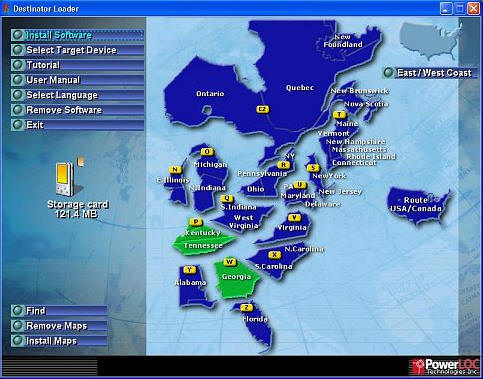
Installing the Destinator software and maps was quick – and I was really
thankful that I already had a 512MB Compact Flash card and
Silver Slider 3 that I could use with my
iPAQ. The Loader was able to tell me my available storage locations…
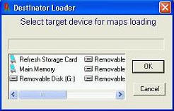
Previously, I had emptied my iPAQ of everything but my Contacts, and I had
also installed a 128MB SD card. When I ran the Destinator program, it easily
found both of my cards and the empty memory in my iPAQ – but after transferring
a couple of maps via iPAQ in cradle, I realized that it would be a lot faster to
use my Keyspan Media Reader,
instead. Picking the maps to install was a matter of clicking the buttons of the
ones I wanted, up to the limit of the memory card I was filling at the time.
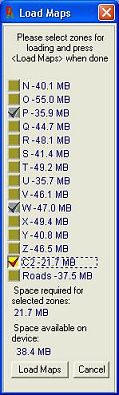
I probably loaded more maps than I will most likely need – but I always like
to be over-prepared.
With my maps installed, I couldn’t help myself; I had to go test out the GPS
in my driveway. Never mind that I didn’t yet have a cradle, never mind that I
wasn’t actually going anywhere – I just wanted to see it work…and after
plugging in the power adapter, putting the GPS module on my dash, and after
attaching the charger/interface cable – it did. I was looking at my
home/position laid out in a map grid with street names and everything. Honestly,
this was a true Zen moment.
But since I still didn’t have a way to mount my Destinator enabled iPAQ
properly, I reluctantly put everything away.
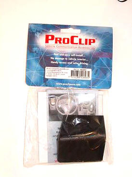
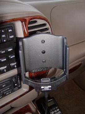
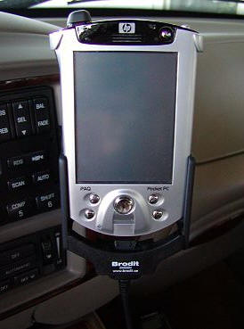
About a week later, I received the ProClip system in the mail. For those of
you that drive a Ford Expedition, these are the part numbers for the items that
I ordered: 848534 – the Compaq iPAQ 3800/3900 (and 5400, might I add) holder
with tilt swivel, and 852693 – the vent clip for 1999-2002 Expeditions. If you
drive a different vehicle or use a different PDA, your cradle and mount will
most likely look a little bit different.
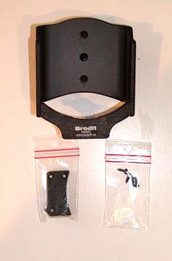
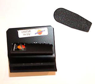
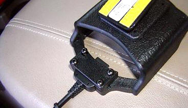
This is the tilt/swivel mounting cradle package, which included the cradle
itself, a bracket to enclose the Destinator’s charger/interface cable, two
very important and very tiny plastic t-bar thingies (for lack
of a better description), and two screws.
The mounting kit included a bracket that would fit between my stereo and AC
vent, and a pry-tool for squeezing the bracket into such a tight spot…
Since I now had everything I needed to become GPS enabled, I gathered up all of
my goodies including a set of screwdrivers, went outside and got to work.
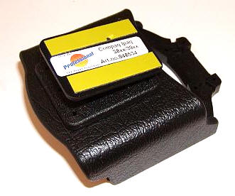
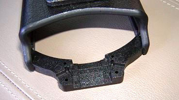
The first order of business was to attach the charging/interface cable to the
cradle. I quickly figured out which way the cable would need to face so that the
iPAQ would properly attach, then laid it in the cradle and attached the
cover-plate. But I forgot something! In my haste, I didn’t put the little t-bar
"thingies" in, which meant that once I installed my iPAQ it would be installed
for life. While that might be acceptable for some, I knew there would be
times when I would need to remove my iPAQ, so I had to back up and install the
t-bars. They keep the sides of the iPAQ plug compressed at all times so that
while the iPAQ will sit securely in the cradle, you can easily slide it in and
out of place.
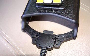
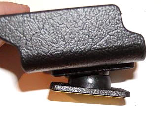
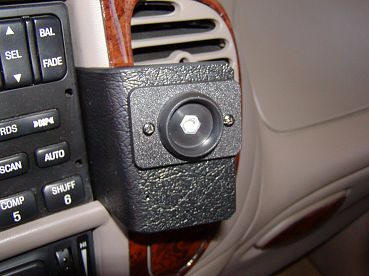
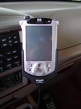
With the cradle ready, I next needed to install the mounting bracket. Using
the pry-tool, I was able to jimmy the plate in between the vent and my stereo.
Next, I unscrewed the swivel portion of the cradle (the big middle screw) and
used the two smaller screws to attach that plate to the mounting bracket. Once
that was firmly attached, I reattached the swivel base to the cradle.
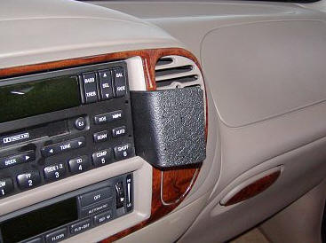
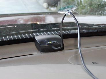
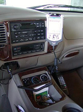
Next, I put the Destinator GPS module on my dash, and attached the suction
cup that would keep it from sliding anywhere…
I plugged the power/charging cord into my lighter, installed my iPAQ, and
Viola – my home/position, in all its mapped glory!
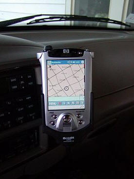
Granted, this is not a factory in-dash system, but I think it looks pretty
good for what it is!
After the installation, all that remained was to actually try out the
system…
For those of you that are as clueless as I was, I am going to give you a
short-course on what GPS is, and how it works. For those of you that are
well-versed in this subject, take a moment and talk amongst yourselves…
The first GPS (Global Positioning System) satellite was launched in the late
1970s for military use only. This allowed better navigation and better weapons
aiming. Like all cool gadgets, it wasn’t long before civilians heard about the
technology, and they wanted it for their own personal and recreational use. The
first consumer products showed up in the 1980s, and in 1984, President Ronald
Reagan declared that a portion of GPS satellites capabilities would be made
available to the civilian market. You can read a bit more about GPS history
here.
It would be best if I now
quote from an excellent article that I found on the history of GPS,
published on the New Mexico Institute of Mining and Technology’s
web site, to explain the following: "Each
of the GPS satellites transmits radio signals. GPS receivers pick up these
signals and measure the distance to a satellite by multiplying the speed of the
signal by the time it takes the signal to get there. The speed of the signal is
the speed of light and the time is encoded within the signal. The satellites
also send information on their exact location.
In order to find longitude, latitude, and altitude, four satellites are
needed. If a measurement is taken using just one satellite, then all that is
known is that the receiver is on the surface of a sphere with radius equal to
the distance to the satellite. If two satellites are used, then the receiver
must be on the surface of both spheres which is the intersection of the two
spheres or the perimeter of a circle. If a third satellite is used, then the
location of the user is narrowed down to the two points where the three spheres
intersect. Three measurements are enough for land receivers since the lower of
the two points would be selected. But when in the air or space, four satellites
are needed: the intersection of all four spheres will be the receiver’s
location. When more than four satellites are used, greater accuracy can be
achieved."
That should give you an overview of GPS, now let’s talk about the Destinator
Navigation System in particular…
According to the Destinator
FAQ, their product is the best because: "Destinator™ is a fully featured
GPS navigation system. As opposed to other GPS mapping systems, Destinator™
tells you not only where you are, but also how to reach your destination in the
most efficient manner. Secondly, the cost is lower than most dedicated in
vehicle navigation systems. Destinator™’s advanced navigation algorithms and
superior map-processing technology makes Destinator a true car navigation system
with features rivaling and surpassing those of permanently installed systems at
a fraction of the cost. With Destinator™, you do not need to pay any additional
monthly charges or fees. Third, it is very portable. Destinator™ can easily be
moved from one vehicle to another. Fourth, your PDA or laptop will now provide
you with all the functionality of a Pocket PC PDA or laptop in addition to the
navigation capabilities. Fifth, Destinator™ uses the highest quality maps
provided by Navigation Technologies. These are the same maps used by FedEx,
OnStar, Mercedes-Benz, Lexus, Jaguar and Porsche just to name a few. Finally,
proprietary patented compression technology puts a larger area of the country
onto the PDA at one time, than is possible with any other product."
All of this sounded great to me – now for the road test!
The first screen you see when you power up Destinator (other than the one
where you enter your activation code) is the following…
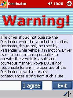 |
This is just a friendly reminder that if you are going to be foolish enough to use the program while you are driving, then it’s your own fault when you wreck. |
Now is the time to do some setting up.
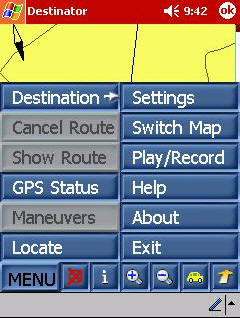 |
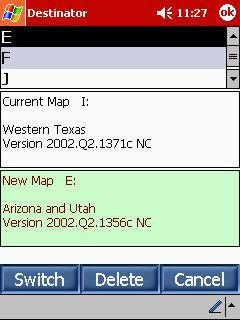
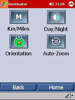
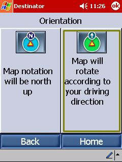
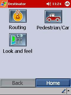
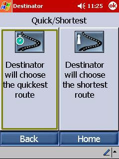
Hitting the Menu button reveals a series of choices. First you should hit Switch Map to make sure that you are in the correct area. Once the correct map is selected, your streets will match your GPS position. Having an incorrect map with a correct GPS position can create some predictable problems. Next, entering Settings allows you to
|
. |
Here are some of the choices you have, and the screens you will encounter…
After setting up my preferences, I decided to key in my HOME position so that
it would always be easy to find my way back from "wherever." To do this, I just
hit the Destination button in Menu, and got this screen…
 |
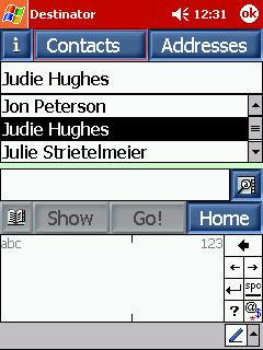
Hitting Contacts allows Destinator to access the addresses in your Pocket Outlook Contacts file. You choose the contact you
|
 |
When you have an address that you need help finding, you hit the
Destination button, then choose the way that you would like to enter the
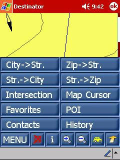
address. My usual way is by hitting the City -> Street button.
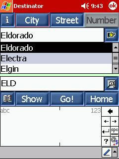 |
After entering the City, you will enter the street, then the number. It will make your life much easier if you remember that you only enter the pertinent information for each tab. In other words, don’t enter the house number you are trying to get to while on the Street tab. I wouldn’t mention this if I hadn’t learned it the hard way… Once your |
 |
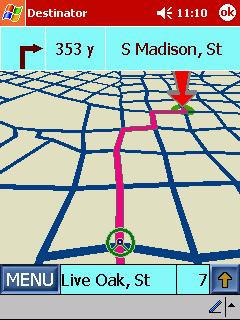 |
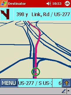
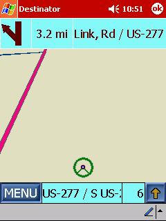
Check it out! 3D trip routing!
This is easily my favorite view. While it doesn’t show you street names, This view is especially handy when you are in areas that have more than |
 |
The Destinator software is easy to use – even for a beginner like me – and it
is intuitive. The entries make sense, and the directions are easy to understand.
Just a few of the pleasant surprises I have received from the system can be seen
in the following screens:
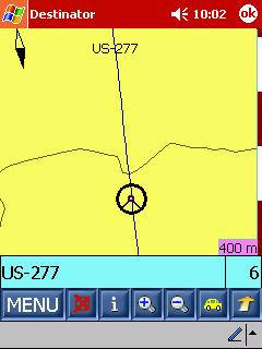 |
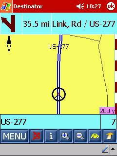
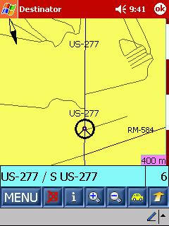
On the left, you can see the highway that crosses the bridge that straddles my family’s ranch. The two lines that cross the highway are the caliche roads that enter each place. I truly never expected to see our ranch roads on my iPAQ. WOW! On the right, you can see another rural One more thing that I have been impressed with, is that it seems as if |
 |
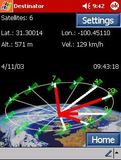 |
I also think that it is quite cool that not only can you see where you are on the map, you can also see where you are in relation to everything. Pushing the GPS Status button shows you how many satellites you are receiving from (in this case, six), as well as your longitude, latitude, velocity and altitude. As you can see, I had accidentally hit the metric button – these items will also display in standard US. |
With that said, there are a couple of little quirks that I have found while
using the system over the past couple of weeks. I am not sure exactly what
brings them on, and they are not really even annoying enough for me to consider
them as cons:
 |
This happened today as I was driving home from the ranch. All of a sudden, according to my iPAQ, I was driving in someone’s pasture…but I wasn’t! After about a hundred yards or so, I was "back on the road." Another little glitch I have seen is that every now and then I will hit a |
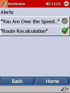 |
One of the Destinator features that I had the most fun with was the one that made my PDA announce we were going "over the speed limit." Personally, I think it is amazing that the software knows this! My husband was going crazy hearing the speed warnings, as he is notorious for his lead foot. Unfortunately, the external speaker on the iPAQ 5455 is so lame that it |
After using the Destinator Personal Navigation System with the ProClip
Vehicle Mount for the last couple of weeks, I can tell you that I am now a
GPS Junkie! I am going to have to add a product such as the
irock! so that I can actually hear the
directions over my stereo speakers, though. Of course, the big "gotcha" with
that idea is that I will not be able to listen to the radio at the same
time…ah well. It’s always something, right?
Prices: $329 for the Destinator Personal Navigation
System, $49.95 for the ProClip cradle, and $29.95 for the ProClip dashboard
mounting plate
Add $250 – $700 for the PDA to use with it
Pros:
Less expensive than a factory GPS system
Can be moved from vehicle to vehicle
Maps are highly accurate
GPS is real time with little to no lag
ProClip is sturdy and swivels for easy passenger viewing
ProClip is made for your PDA and vehicle, and fits interior accordingly
Cons:
It’s still expensive – but then, that is relative isn’t it?

HP 14 Laptop, Intel Celeron N4020, 4 GB RAM, 64 GB Storage, 14-inch Micro-edge HD Display, Windows 11 Home, Thin & Portable, 4K Graphics, One Year of Microsoft 365 (14-dq0040nr, Snowflake White)
(as of May 14, 2026 12:06 GMT -05:00 - More infoProduct prices and availability are accurate as of the date/time indicated and are subject to change. Any price and availability information displayed on [relevant Amazon Site(s), as applicable] at the time of purchase will apply to the purchase of this product.)
HP Chromebook 14 Laptop, Intel Celeron N4120, 4 GB RAM, 64 GB eMMC, 14" HD Display, Chrome OS, Thin Design, 4K Graphics, Long Battery Life, Ash Gray Keyboard (14a-na0226nr, 2022, Mineral Silver)
(as of May 14, 2026 12:10 GMT -05:00 - More infoProduct prices and availability are accurate as of the date/time indicated and are subject to change. Any price and availability information displayed on [relevant Amazon Site(s), as applicable] at the time of purchase will apply to the purchase of this product.)Product Information
| Price: | |
| Manufacturer: | Destinator |
Gadgeteer Comment Policy - Please read before commenting
Post your comments here on the Destinator Personal Navigation System for Pocket PC (Installed in Vehicle with ProClip System).
http://www.the-gadgeteer.com/destinator-proclip-review.html
Just click the POST REPLY button on this page.
The Destinator is a bit on the expensive side. There are cheaper alternatives that do basically the same job with the same Navtech datasets. Nice review, but I am more than happy with my Socket Bluetooth GPS, Dell Axim X5 (with CF Bluetooth Card) and a copy of Mapopolis. No messy wires to deal with.
Clean car !:D
Judie, welcome to the GPS Junkies club! I was so excited when I got my first GPS that I drove to the UPS terminal to pick it up in person and installed it in the parking lot! Took it a couple of minutes to figure out where it was the first time it woke up, but I drove home with it on.
One thing I did not like was that the StreetFinder software had no rotation ability, despite the cool looking maps. Also, there was no way it could do a route unless you ran it on the desktop/laptop AND had a live internet connection. I switched to Mapopolis and have been a happy camper ever since.
One question; does your GPS use WAAS? It should be in the manual for the GPS device itself.
I have Destinator 2.0, it’s a pretty good program but I have some issues with it. If you lose power to the gps, you have to restart destinator and re enter the destination for instance. I am trying Mapopolis and I’m really liking it so far. It is much faster for things like accessing contacts and re-routing. You can turn your car off at a gas station and when you restart Mapopolis picks up like nothing happened. It’s also cheaper than Destinator. The only thing I miss is the 3-d view mode. I also like the flexibility of being able to load individual county maps and route across them seamlessly. I’m about to buy Mapopolis, just trying to decide between the CD or Subrsciption
aflan,
Since I usually leave my iPAQ in the cradle and powered up (even at night) I hadn’t really had a problem with having to restart destinations, like that.
When I do remove my iPAQ from the cradle (like at the mall or places like that), I generally exit the program anyways, restarting everything when I get back.
I realize that the program is pricey, but since there is no additional subscription to pay for I think it balances out.
The 3-D view is my favorite, so it would be hard for me to switch to another brand for any reason. Isn’t it funny how there are special little things that are deal-breakers for us all when it comes to using something other than that which we are satisfied with?
Judie
>>I realize that the program is pricey, but since there is no additional subscription to pay for I think it balances out.<<
Hum… not tracking here. Destinator software and maps CD costs $250. Mapopolis maps CD (app is free) costs $110. How does that balance out? 🙂 Do you get free map updates with Destinator?
Not that I am being picky here, I dont want to come across as an advocate for Mapopolis. There are, as we all know, a number of options out there. TeleType, Mapopolis, Pharos, Delorme Xmap etc. All a question of finding a bearable pricepoint and the set of features you require.
>>The 3-D view is my favorite<<
Tisk, tisk… you’re not supposed to be looking at the display, that is what the nice mellifluous voice is for…
>>Hum… not tracking here. Destinator software and maps CD costs $250. Mapopolis maps CD (app is free) costs $110. How does that balance out? Do you get free map updates with Destinator? <<
Yes, to the best of my knowledge, you do. That’s why they have you register when you purchase. If someone knows differently, please advise.
>>>>The 3-D view is my favorite<<<<
>>Tisk, tisk… you’re not supposed to be looking at the display, that is what the nice mellifluous voice is for…<<
Ah, but you are asuming that I am always the driver. Actually, I am quite often the co-pilot – especially on trips. 😉
Judie :0)
Judie,
Why Quit the program if you are making a short stop on your way to the main destination? Mapopolis lets you stop, turn off the Ipaq and/or Gps, and start up seamlessly. It’s one of my pet peeves that none of the pocket pc mapping systems allows
Stops to be entered in a route on the fly. This would allow forcing the program to avoid areas you know you don’t want to go through!, or forcing it to take roads you like. I don’t know about you, but most of my trips are multi-stop.
Have a good one
Allen
aflan,
You misunderstood what I wrote, or I (most likely) wasn’t clear enough.
I wasn’t even thinking of having an entered destination when I stop somewhere that I would want to remove the iPAQ from its cradle. Generally I will enter where I am going and other than stopping for a meal or gas, I don’t make any stops. Or my destination willl be the stop. Otherwise, as long as my iPAQ is in the ProClip cradle it is receiving power from my cigarette lighter, so my route is not lost and my iPAQ never turns off.
I can totally see where it would be handy to enter multiple stops on the fly, tho. Maybe v3.0. 🙂
Judie :0)
has anyone tried this new mapping software.. FREE..
http://www.mapopolis.com/cooltraffic.jsp
F.
Yes, I’m using Mapopolis now and I love it. I’m not seeing much use for Clearroute though. I doesn’t seem to give accurate info in the south bay area of California. I’ve never seen a route change due to traffic or seen any traffic warnings.
Allen
Your problem of where it resets is a software/hard glitch on your ipaq. Your GPS probably uses only minimum of 3 of the sattlites need for a precise location, and when one sat get’s weak, it will hand off to another one of the other ones. The hard/software probably doesn’t do this handoff properly, as it is a suprisingly complex process. It is simular to when you roam and talk with your cell phone while driving you won’t get disconnected and will switch over to a different basestation/provider. How’s that for technicals.
I’m not sure of the hardware specs for this device, but most of them aquire more than the minimum just so handoffs don’t kill the trig functions. The only time I’ve had less than 5 locks on my Navman was during a snowstorm with whiteout conditions. Perhaps her device is setup to use the minimum?…
Most of the time for me, 6 to 9 locks are normal. The most I’ve ever had is 12 aquired at the same time, but like you mentioned, it can calc my location after the first 3.
I’ve never had a reset while using the GPS, but there has been two times where My Palm would not talk to the GPS until I did a soft reset.
Paul
For a 3D position, the unit has to track 4 SVs (Satellite Vehicles). Current recievers have 12 parallel channels. The early units had 2 channels and would multiplex. One channel would lock onto a specific PRN (Pseudo random number – one unique number per SV) and recieve the navigation message. While this was happening the other channel would be skipping between the SVs to see which ones were in view. So, these recievers would be skipping from one SV to another receiving one navigation message at a time and then calculating a position.
Satellite hand off is not the issue, the recievers have ways to cope. On most recievers even if you loose lock (going through a tunnel for example) the NMEA stream will still output your last position but it is tagged as an old position. Garmin units have a dead recokning function. If it looses *all* lock can can no longer even calcualte a 2D position (3 SVs) it will perform dead recokning for 30 seconds, basically, it will maintain your bearing and velocity for 30 seconds after loss of lock, only then alerting you to the fact that GPS lock has been lost.
Your GPS will use the 4 satellites in view with the best geometry, if you look at the GPS detail page, that is what the PDOP is telling you (Point Dilution of Precision). Turning off the GPS (no NMEA stream) verses no lock (NMEA stream with no position in the $GPGGA sentence) are two different things. From the original post, it seems that when the GPS was turned off, the mapping application would have to be restarted as it would not reconnect to the GPS it if was turned on again.
Judie, thanks for the great review. Exactly what I have been looking for.
OTOH, for me I only have a Clie NR70V and a semi-retired N760C. Is there any solution for the Palm side?
Or how about a solution for the iPaq 1910? I am thinking of switching to that, but don’t see any solution for that PocketPC yet.
I bought a 2007 Mitz. Endeavor SUV. I don’t smoke so I didn’t warry about not having a cigarette lighter in my truck. Now, I want to purchase a GPS Navigator, and I need to charge my cell phone. Would it be very exspensive to have a cigarette lighter installed? Where can i go to have one installed?
Thank you,
Ms. Taylor
[email protected]
@Mary E. Taylor Your SUV doesn’t have a power port at all? That’s hard to imagine. I think all vehicles have at least one 12v port. Look around the center console and see if there’s a port with a circular cap over it. If not, go to a Mitsubishi dealer and ask about getting one installed.